
 |
|||||||||
 |
 |
 |
|||||||
April 25, 2024, Montreal, Quebec, Canada – TheNewswire – Beauce Gold Fields (Champs D’Or en Beauce) (TSX Venture: “BGF”), also known as “BGF” or the “Company,” is delighted to announce that geochemical soil sampling results have identified a suite of anomalous elements corresponding with the mineralized gold zones of the Grondin antiform outcrop on the Company’s Beauce Gold property located in Beauceville, Quebec. This demonstrates that soil sampling, along with geophysics, will be an invaluable tool to delineate antiform structures for drilling targets.
Patrick Levasseur, President and CEO of Beauce Gold Fields, states, “This evidence suggests that soil sampling is a cost-effective exploration method for tracing the mineralized structures identified as the source of the historic placer gold deposits. We continue to pursue potential mineralized structures, which show great promise for further lode gold discoveries.”
Click Image To View Full Size
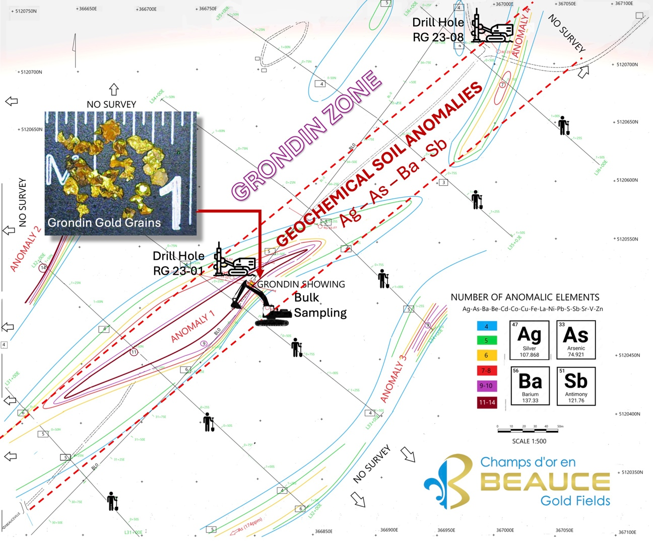
Image 1: Grondin Gold Zone Geochem Soil Anomaly, Inset: Bulked Sampled Gold Grains
Soil Geochemistry on the Grondin Gold Zone
In the fall of 2023, a total of 88 soil samples were collected from six parallel grid lines spaced 100 meters apart. Out of the 36 chemical elements that were analyzed by pyroanalysis, 16 have been selected for their relevance in characterizing the Grondin gold-bearing zone. These elements are: Ag, As, Ba, Be, Cd, Co, Cu, Fe, La, Ni, Pb, S, Sb, Sr, V, and Zn. Predominantly, these are the elements that have shown anomalies in either the 35 lithogeochemical drill samples (as per the Drill Hole RG 23-01 press release on January 18, table 1) or within the 88 soil samples themselves.
Table 1: Anomalous elements directly associated with the highest gold grades in RG 23-01
|
Au |
Ag |
As |
Ba |
Ce |
Sb |
La |
Zn |
W |
Zr |
|
|
Sample |
0,01ppm |
0,01ppm |
0,2ppm |
10ppm |
0,02ppm |
0,5ppm |
0,5ppm |
2ppm |
0,1ppm |
0,5ppm |
|
CO247001 |
0 |
0,03 |
48.9 |
652 |
9.98 |
<0.5 |
4.7 |
71 |
33 |
27.0 |
|
CO247002 |
1,2 |
0,2 |
249.1 |
1678 |
44.62 |
0.8 |
21.0 |
125 |
64 |
117.1 |
|
CO247003 |
1 |
0,42 |
356.7 |
3082 |
78.00 |
1.4 |
34.7 |
60 |
73 |
239.0 |
|
CO247004 |
1,5 |
0,36 |
468.0 |
3955 |
159.72 |
1.5 |
89.1 |
51 |
102 |
252.0 |
|
CO247005 |
2,4 |
0,44 |
752 |
3684 |
82.76 |
1.3 |
42.7 |
51 |
101 |
228.7 |
|
CO247006 |
2,6 |
0,57 |
2752 |
2106 |
51.99 |
2.3 |
26.1 |
52 |
69 |
135.0 |
|
CO247007 |
1,5 |
0,35 |
1546 |
2263 |
50.95 |
1.2 |
25.2 |
50 |
72 |
149.1 |
|
CO247008 |
0,16 |
0,09 |
228 |
440 |
13.72 |
<0.5 |
6.6 |
38 |
20 |
31.7 |
|
CO247009 |
0,2 |
0,1 |
168 |
521 |
9.69 |
<0.5 |
4.8 |
14 |
19 |
26.1 |
|
CO247010 |
0,027 |
0,08 |
24 |
154 |
5.55 |
<0.5 |
2.8 |
6 |
6 |
9.6 |
|
CO247011 |
0,03 |
0,1 |
8,3 |
61 |
4.00 |
<0.5 |
1.9 |
3 |
2 |
3.5 |
|
CO247012 |
0,017 |
NR |
9,4 |
105 |
2.64 |
<0.5 |
1.2 |
5 |
5 |
7.2 |
|
CO247013 |
0,05 |
0,07 |
42,5 |
406 |
6.65 |
<0.5 |
3.3 |
13 |
19 |
23.5 |
|
CO247014 |
0,05 |
0,07 |
34 |
116 |
2.33 |
<0.5 |
1.1 |
7 |
5 |
7.5 |
|
CO247015 |
2,4 |
0,76 |
638,3 |
1214 |
42.15 |
2.0 |
21.9 |
100 |
76 |
63.6 |
|
CO247016 |
3 |
0,79 |
706,9 |
2274 |
78.82 |
3.2 |
40.1 |
36 |
113 |
141.7 |
|
CO247017 |
2,9 |
0,66 |
974,6 |
2462 |
74.61 |
3.9 |
37.3 |
99 |
140 |
111.2 |
|
CO247018 |
6,3 |
1,63 |
1696,2 |
2756 |
184.54 |
5.0 |
100.3 |
177 |
172 |
132.0 |
|
CO247019 |
11,4 |
1,77 |
350,8 |
4463 |
259.45 |
2.5 |
146.2 |
43 |
225 |
210.0 |
|
CO247020 |
0,37 |
0,2 |
304,5 |
1540 |
43.46 |
1.6 |
22.6 |
131 |
87 |
67.0 |
|
CO247021 |
0,07 |
0,06 |
19 |
378 |
8.13 |
0.5 |
3.9 |
31 |
13 |
20.8 |
|
CO247022 |
0,01 |
0,03 |
14,2 |
155 |
2.85 |
<0.5 |
1.4 |
4 |
9 |
5.9 |
|
CO247023 |
0,09 |
0,05 |
268 |
1548 |
31.58 |
1.0 |
15.2 |
61 |
76 |
75.9 |
|
CO247024 |
1,5 |
0,21 |
410 |
473 |
43.46 |
0.01 |
12.1 |
46 |
30 |
40.1 |
|
CO247025 |
Blank |
0,07 |
15,5 |
1208 |
8.13 |
1.09 |
38.4 |
87 |
122 |
111.9 |
|
CO247026 |
Standard |
NR |
NR |
NR |
NR |
NR |
NR |
NR |
NR |
NR |
|
CO247027 |
1,3 |
0,69 |
1240 |
2931 |
31.58 |
0.07 |
19.9 |
286 |
51 |
63.4 |
|
CO247028 |
0,947 |
0,18 |
232 |
117 |
24.00 |
<0.01 |
2.9 |
28 |
6 |
8.2 |
|
CO247029 |
1,7 |
0,85 |
340,8 |
865 |
75.00 |
0.04 |
17.7 |
123 |
45 |
45.6 |
|
CO247030 |
1 |
0,51 |
242,2 |
338 |
NR |
<0.01 |
6.8 |
75 |
8 |
11.1 |
|
CO247031 |
0,02 |
0,05 |
22,4 |
36 |
38.65 |
<0.01 |
1.2 |
5 |
2 |
2.2 |
|
CO247032 |
0,015 |
0,05 |
3,4 |
17 |
5.47 |
<0.01 |
<0.5 |
2 |
<1 |
<0.5 |
|
CO247033 |
0,033 |
0,05 |
2,7 |
17 |
0.60 |
<0.01 |
<0.5 |
2 |
<1 |
0.7 |
|
CO247034 |
0,048 |
0,23 |
6,9 |
31 |
0.68 |
<0.01 |
<0.5 |
2 |
<1 |
1.2 |
|
CO247035 |
0,166 |
0,1 |
21,4 |
40 |
3.15 |
<0.01 |
1.7 |
3 |
2 |
2.3 |
A map (refer to Image 1) that displays the distribution of geochemical anomalies at a 1:500 scale is derived from the soil geochemistry survey and highlights four significant soil anomalies. The thresholds for defining an anomaly for each element were set to accentuate the highest concentrations observed in this survey. In some cases, these anomaly thresholds may exceed the detection limit by over 100 times (as detailed in Table 2).
Barium stands out as the element most frequently associated with the geochemical anomalies, with concentrations reaching up to 130 times above the detection limit. The sections of the gold-mineralized drill core RG 23-01 have also shown a strong correlation with high barium levels, reaching up to 4000 ppm (table 1). Additionally, arsenic and antimony are noted as reliable indicators of gold mineralization within our area of interest. According to Boyle (1974), arsenic substitutes for Fe in pyrite, particularly pyrite associated with gold mineralization and base metal mineralization. It would also be a very good universal indicator of mineralization. Its mobility, combined with its normal distribution, makes it an excellent work tool.
Table 2: Anomaly threshold for soil samples:
|
Element |
Detection Limit |
Anomaly Threshold |
Concentration Factor |
|
Ag |
0,2 ppm |
0,25 ppm |
X 1,25 |
|
As |
2 ppm |
30 ppm |
X 15 |
|
Ba |
10 ppm |
60 ppm |
X 6 |
|
Be |
0,5 ppm |
0,8 ppm |
X 1,6 |
|
Cd |
0,5 ppm |
0,6 ppm |
X 1,2 |
|
Co |
1 ppm |
10 ppm |
X 10 |
|
Cu |
1 ppm |
9 ppm |
X 9 |
|
Fe |
0,01 % |
3% |
X 30 |
|
La |
10 ppm |
15 ppm |
X 1,5 |
|
Ni |
1 ppm |
25 ppm |
X 25 |
|
Pb |
2 ppm |
20 ppm |
X 10 |
|
S |
0,01% |
0,15% |
X15 |
|
Sb |
2 ppm |
3 ppm |
X 1,5 |
|
Sr |
1 ppm |
9 ppm |
X 9 |
|
V |
1 ppm |
20 ppm |
X 20 |
|
Zn |
1 ppm |
100 ppm |
X 100 |
To visualize the geochemical anomalies, classes that group together 4 to 14 anomalous elements have been retained. The map shows isocontours of 6 different colors, which have been chosen according to the number of anomalous elements.
ANOMALY 1: GRONDIN ZONE (Ag-As-Ba-Sb)
The Grondin zone responds well to soil geochemistry. On the index and around, groups of anomalous elements ranging from 4 to 11 are noted. The core of the anomaly contains from 9 to 11 elements, some of which are strongly anomalous, including arsenic, which goes from 223 to 689 ppm (BLO-32+50E). Anomaly 1 stretches over more than 250m in length and between lines 31E and 34E and remains open towards the SW.
The most significant elements that emerge in this anomaly 1 are silver, arsenic, barium, rare earths, and antimony. Anomaly 1 contours the drill holes drilled into the Grondin mineralized gold structure.
ANOMALIES 2 AND 3:
The 2023 soil geochemistry survey covered the Grondin index over an area of approximately 500m X 300m. A baseline of 500 meters in length was drawn parallel to the Grondin gold-bearing structure oriented at approximately N40°. This line was connected to 6 other transverse lines each measuring 300 meters in length. The transverse lines, spaced 100 meters apart, were drawn to intersect the Grondin zone at 90°. For this first attempt, the lines were drawn to cover the zone over 150m to the NW and 150m to the SE of the baseline.
ANOMALY 2:
Anomaly 2 is the most significant of the survey with the exception of anomaly 1. It alone groups 14 of the 16 elements, with barium having the highest content of the 88 soil samples, i.e., 259 ppm Ba. Silver, base metals, and antimony stand out among the other anomalous elements. The sample was taken on line 32E at station 1+50N, at the edge of the geochemistry survey. Its shape and length cannot be determined; however, it seems to be directed towards the NE-SW and would be outside the perimeter of the 2023 survey.
ANOMALY 3:
This anomaly 3 is located on line 34EST at station 1+50S and once again at the southern limit of the 2023 survey. Anomaly 3 groups together 9 anomalous elements including barium and zinc. Moreover, it extends towards the SW and would be related to a high arsenic content at 174 ppm As.
ANOMALY 4:
It is found at the NE end of the survey and would be +/- associated with anomaly 1. It remains weak but is located above the gold-bearing zone found in the RG 23-08 drill. Anomaly 4 suggests that the Grondin zone extends towards the NE.
About the Grondin Gold Zone
The Grondin Zone is located in the northwest corner of the Beauce Gold property located in Beauceville and in Saint-Simon-les-Mines, Quebec. The 2023 exploration initiatives at the Grondin Zone, comprising both bulk processing and drilling, (BGF press releases, November 1 2023 and January 18 2024) revealed that the Grondin zone extends over 40 meters deep vertically and remains open at depth, with a mineralized structure stretching more than 300 meters in length. This zone is intrinsically linked to an antiform fold axis that spans several kilometers, suggesting that other gold showings may be present along the antiform fold and elsewhere on the Beauce Gold property.
The geology of the Grondin Zone consists of laminated zones and fault mirrors developed in volcanic rock (lapilli tuff) but mainly in black, graphitic, and highly deformed argillite. These significant shearings can lead to a substantial loss of drilling core volume. Ductile deformation affected the mineralized zone, causing boudinage of the quartz veins. The shear faults have greatly facilitated the circulation of mineralizing fluids, particularly along contacts between competent/incompetent rocks. The mineralized rock has been altered by green chlorite and sericite, which make the graphite shiny and silky.
The Company’s diamond drilling and hard rock bulk sampling indicates a significant potential for lode gold discoveries from this gold structure. The gold was found both as sulfides and in free form, suggesting a considerable system likely established northwest of Saint-Simon-les-Mines. A positive correlation applies to silver and the pathfinder elements that were identified for the Grondin zone and in the basal till and the saprolite of the gold channel of the Gilbert River valley. (press release January 18, 2024) This system could have contributed to the development of supergene deposits and extensive auriferous placers in Beauce.
The Company plans to conduct geophysics along the Grondin structure to confirm it’s dip, depth & length.
Jean Bernard, B,Sc. Geo., is a qualified person, as defined by NI 43-101, who has reviewed and approved the technical information presented in this release. QA/QC procedures for the reported soil sampling include Certified Reference Materials from MSALABS Test Certificate YVO2410178. ICP 130 analytical method used on the 88, 500 gram soil samples.
About Beauce Gold Fields
Beauce Gold Fields is focused on exploring and developing the largest placer gold district in eastern North America. The Company’s objective is the trace old placer gold workings back to a bedrock source to uncover economic lode gold deposits. The Company’s flagship property is the St-Simon-les-Mines Gold project site of Canada’s first gold rush that pre-dates the Yukon Klondike. The Beauce region hosted some of the largest historical placer gold mines in Eastern North America that were active from 1860s to the 1960s It produced some of the largest gold nuggets in Canadian mining history (50oz to 71oz). (Source Sedar: 43-101 Report – Beauce July 4th 2018, , Author B. Violette)
Beauce Gold Fields website www.beaucegold.com
Disclaimers:
This press release contains certain forward-looking statements, including, without limitation, statements containing the words “may”, “plan”, “will”, “estimate”, “continue”, “anticipate”, “intend”, “expect”, “in the process” and other similar expressions which constitute “forward-looking information” within the meaning of applicable securities laws. Forward-looking statements reflect the Company’s current expectation and assumptions, and are subject to a number of risks and uncertainties that could cause actual results to differ materially from those anticipated. These forward-looking statements involve risks and uncertainties including, but not limited to, our expectations regarding mineral exploration. Such statements reflect the current views of the Company with respect to future events and are subject to certain risks and uncertainties and other risks detailed from time-to-time in the Company’s on-going filings with the securities regulatory authorities, which filings can be found at www.sedar.com. Actual results, events, and performance may differ materially. Readers are cautioned not to place undue reliance on these forward-looking statements. The Company undertakes no obligation to publicly update or revise any forward-looking statements either as a result of new information, future events or otherwise, except as required by applicable securities laws.
Neither the TSX Venture Exchange nor its Regulation Services Provider (as that term is defined in the policies of the TSX Venture Exchange) accepts responsibility for the adequacy or accuracy of this release.
For further information contact
Patrick Levasseur, President and CEO Tel: (514) 262-9239
www.beaucegold.com
Copyright (c) 2024 TheNewswire – All rights reserved.